Most building permit rejections in Perth don’t happen because the structure was too big or too close to a boundary. They happen because the site plan itself was incomplete, unclear, or drawn to the wrong standard. Council assessors work through dozens of applications a week — and they know within seconds whether a drawing will give them what they need. This guide breaks down exactly what they check, what triggers a Request for Further Information (RFI), and how to make sure your site plan gets assessed cleanly the first time.
Why Your Site Plan Is the Most Critical Document
When a council assessor picks up your building permit application, the site plan is the first thing they look at — and in many cases, the only thing standing between approval and an RFI that adds weeks to your timeline.
A site plan is not just a diagram of where your patio or shed will sit. For a council assessor, it is the primary compliance document. It needs to prove, at a glance, that your proposed structure meets the Residential Design Codes of Western Australia (R-Codes), the Building Act 2011, and any local planning policies set by your specific council.
Get it right, and assessment is fast and straightforward. Get it wrong — even with a perfectly compliant structure — and you face delays, additional costs, and the frustration of resubmitting.
A Request for Further Information (RFI) from your council can add 2 to 6 additional weeks to your approval timeline. Most RFIs are triggered not by non-compliant structures, but by incomplete or unclear site plans. Getting your drawing right the first time is the single most effective way to speed up council approval.
The 8 Things Perth Council Assessors Check First
Based on over 15 years of experience preparing council approval drawings across Perth and Western Australia, here are the eight elements assessors look for immediately when reviewing a site plan.
01
Correct Scale & North Point
Your site plan must be drawn to a stated scale — typically 1:200 or 1:500 — with a north point clearly marked. An unscaled or unlabelled drawing cannot be assessed and will trigger an RFI immediately.
03
Accurate Setback Dimensions
This is the single most scrutinised element on any site plan. Assessors check that the proposed structure is set back the correct distance from every boundary — front, side, and rear — in accordance with the R-Codes and your local council’s planning policies.
05
Proposed Structure Fully Dimensioned
The proposed structure — whether a patio, carport, shed, or retaining wall — must be shown with all external dimensions clearly labelled. Length, width, and any relevant internal measurements must be readable at the plan’s stated scale.
07
Easements & Encumbrances Noted
If the property has any easements — drainage, sewerage, or access easements — these must be shown on the site plan. Building over or within an easement requires additional approval. Missing this information is a common and costly oversight.
02
All Property Boundaries Shown
Every boundary of the lot must be clearly drawn and dimensioned, including the full lot width, depth, and any irregular angles. The lot area in square metres should also be stated. Assessors use this to calculate setback compliance and site coverage.
04
Existing Dwelling Clearly Shown
Your existing home must be drawn on the site plan with its dimensions and position on the lot. Assessors need to see the relationship between the proposed structure and the existing dwelling — particularly for attached structures like patios and carports.
06
Street & Lot Address Labelled
The property street address and lot number must appear on the drawing. This seems obvious, but it is one of the most commonly missing details on DIY-prepared site plans, and it will result in an RFI.
08
Site Coverage Calculation
Many councils require the total site coverage to be calculated and shown on the plan. This is the combined footprint of all structures on the lot as a percentage of the total lot area. Your R-Code density determines the maximum allowable site coverage.
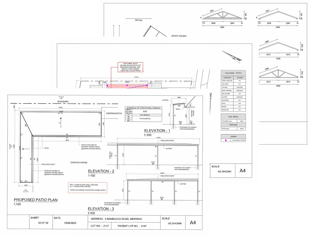
What a Council-Ready Site Plan Looks Like
The diagram below shows the key elements every WA council site plan must include. All of these must be present, correctly labelled, and drawn to scale for your application to be assessed without an RFI.
Setbacks: The Number One Reason Applications Are Delayed
Of all the elements on a site plan, setback compliance is the area that consumes the most assessor time — and causes the most RFIs. Understanding how WA councils assess setbacks is essential for anyone preparing their own site plan.
Setbacks: The Number One Reason Applications Are Delayed
Under the Residential Design Codes (R-Codes), setbacks are measured from the lot boundary to the nearest part of the structure — including eaves and roof overhangs in some cases. This is a common point of confusion: many homeowners measure to the wall of the structure, not accounting for the roof overhang that may encroach further toward the boundary.
The R-Codes set state-wide minimum standards, but every Perth council has the authority to apply stricter requirements through Local Planning Policies. The City of Joondalup, City of Swan, and Shire of Mundaring, for example, all have specific policies that modify standard R-Code setbacks. Always check your specific council’s requirements before preparing your site plan.
The 7 Most Common Site Plan Mistakes That Cause Delays
These are the errors Plan Works Australia sees most frequently on DIY-prepared site plans — all of which result in an RFI and weeks of delay.
What Elevation Drawings Add to the Assessment
A site plan alone is rarely sufficient for a building permit application in WA. Council assessors also require elevation drawings — front, side, and rear views of the proposed structure — to assess height compliance, roof pitch, and visual impact.
For patios, elevation drawings must clearly show the height to the underside of the roof (the eave height) and the height to the ridge or highest point of the roof. For carports, assessors check whether the structure will be visible from the street and whether the roof profile is appropriate for the streetscape.
Elevation drawings must also be drawn to a stated scale — typically 1:100 or 1:200 — and must dimensionally agree with the site plan. Inconsistencies between the site plan and elevation drawings are a common cause of RFIs, as assessors cannot determine which set of dimensions is correct.
Frequently Asked Questions
The R-Codes set minimum state-wide standards that apply across all WA councils. However, individual councils can and do apply stricter requirements through Local Planning Policies. What satisfies one council may not satisfy another. Plan Works Australia prepares drawings aligned with the specific requirements of your local council.
Yes — as the property owner, you are permitted to prepare and lodge your own site plan in WA. However, it must meet all of the technical requirements described in this article. Errors or omissions will result in an RFI and delays. Plan Works Australia provides professionally prepared, council-ready site plans that meet WA assessment standards, starting from $350.
A Request for Further Information (RFI) is a formal notice from your council asking you to provide additional documentation or correct errors in your application. It pauses the assessment clock and typically adds 2 to 6 weeks to your approval timeline. The most reliable way to avoid an RFI is to submit a complete, correctly scaled site plan that addresses all of the elements listed in this article before lodging.
Not always. If your patio meets the R-Codes deemed-to-comply setback and size requirements, planning approval is generally not required and you can proceed directly to a building permit application. If your patio does not meet these requirements — for example, if it is longer than 9 metres along a wall or closer than 1.5 metres to a boundary — planning approval will be required first. The DIY Council Approval Guide included with every Plan Works Australia drawing package explains exactly how to determine this for your project.
Site coverage is the total footprint of all structures on your lot — including the existing home, any sheds, garages, patios, and the proposed new structure — expressed as a percentage of the total lot area. For example, if your lot is 600m² and all structures combined cover 240m², your site coverage is 40%. The maximum allowable site coverage depends on your R-Code density, but is typically between 50% and 60% for residential properties in Perth.
Get a Council-Ready Site Plan in 4 Days
Plan Works Australia prepares professional site and elevation plans for patios, carports, sheds, and retaining walls across Perth and Western Australia — drawn to WA council standards, with our step-by-step DIY Council Approval Guide included at no extra cost.